
Pīpīwai TrailOn the trail
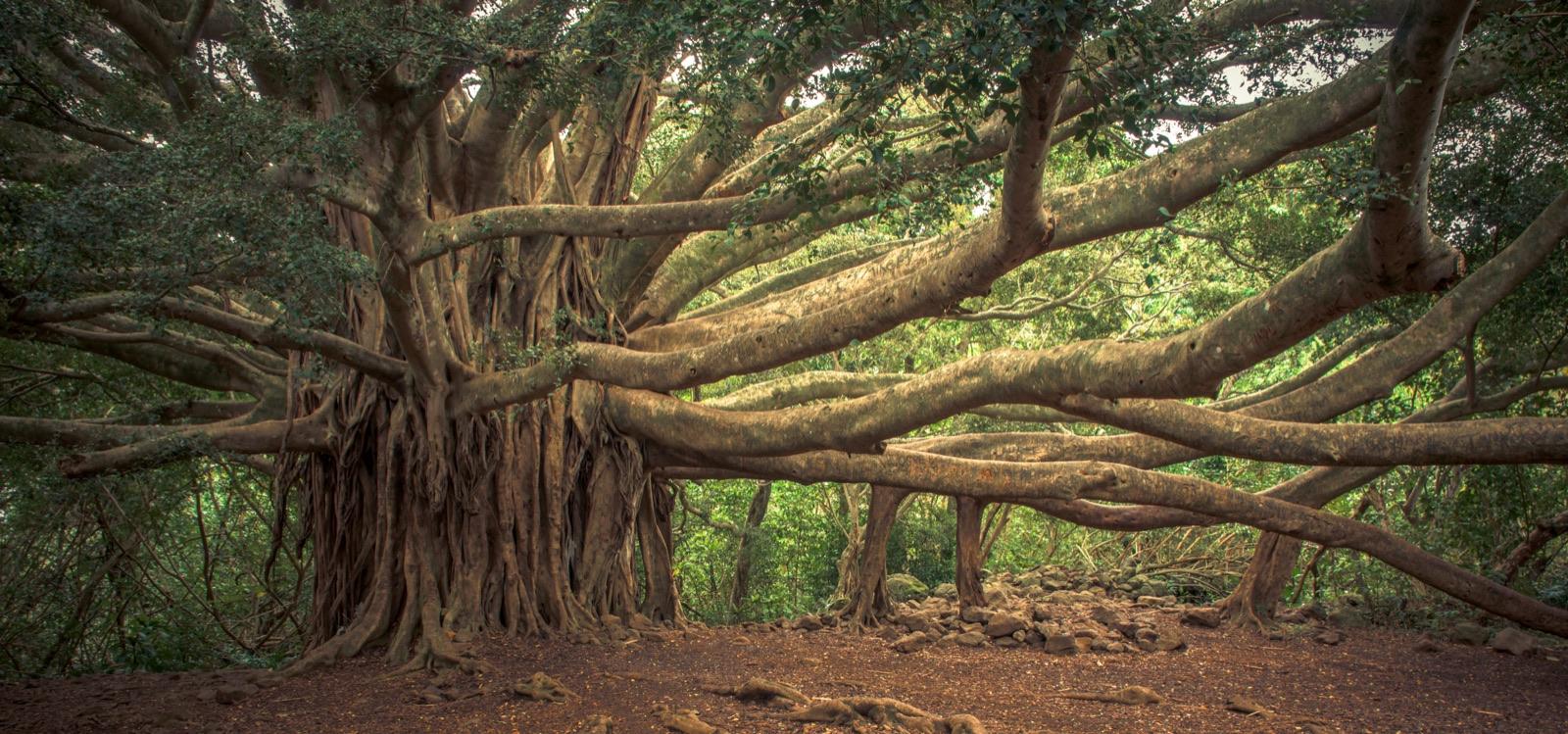
The Pīpīwai Trail Banyan Tree
Last checked 2026-08-23
Wikimedia Commons, Banyan Tree, Pipiwai Trail
The giant banyan sits at 0.7 miles, about 7 minutes past the Makahiku overlook and just beyond a gate across the trail. Figure 27 minutes from the trailhead at an easy pace. It has a footprint about the size of a house, with aerial roots dropped from horizontal limbs and thickened into trunks of their own, and it is the point where the climbing eases off for a while.
| Question | Answer |
|---|---|
| Distance from the trailhead | 0.7 miles |
| Time from the trailhead | About 27 minutes |
| Cumulative climb | 490 ft |
| After Makahiku Overlook | 0.2 miles, about 7 minutes |
| Before the bridge | 0.2 miles |
| Landmark to watch for | A gate across the trail. The tree is immediately past it. |
Pīpīwai stops in this district
- 1
0.5 mi · First waterfall view
- 2
~1 mi · Boardwalks and footbridges
- 3
2 mi one way · 400 ft falls
How far is the banyan tree on the Pīpīwai Trail?
0.7 miles from the trailhead. You reach it about 7 minutes after the Makahiku overlook, 0.2 miles further along, and the landmark to watch for is a gate across the trail with the tree immediately beyond it. Total climb to this point is 490 feet, and most walkers arrive within 27 minutes of leaving the car.
You will see other numbers. Some pages put the banyan at half a mile, others at a full mile, and several just say it is past Makahiku somewhere. It sits between those two figures, closer to the overlook than to the bamboo, and the gate is what settles it on the ground. If you are through the gate and the trail has flattened out, you are there.
From the banyan it is 0.2 miles to the bridge and 0.3 miles to the start of the bamboo, so this is not a turnaround so much as a landmark that tells you the hard part is over.
How big is the banyan?
Big enough that you walk through it rather than past it. The canopy and root system together cover a footprint about the size of a house, and the trail runs along the edge of that footprint, so for thirty or forty seconds the tree is on both sides of you and above you at the same time.
The trunk is not really a trunk. What you are looking at is a cluster of them, some the diameter of a barrel and some no thicker than a wrist, standing in a loose colonnade under limbs that run out sideways instead of up. The bark is smooth and grey and worn shiny at hand height where thousands of people have touched it. Light comes through in patches. It is dim, still, and noticeably quieter in there than on the open trail, and it is the one place on this hike where you are inside a single living thing rather than in a forest.
How does a banyan grow like that?
The limbs do the work. A banyan sends roots downward out of its horizontal branches, thin dangling threads at first, moving with any breeze and reaching for nothing in particular. Most of them dry out and die. The ones that reach soil anchor, take up water, and then thicken year after year until they are load-bearing columns that hold up the branch that produced them.
Once a limb is supported it can keep extending, put down another root, and be supported again, so the tree advances sideways across the ground indefinitely rather than growing taller. That is why the shape is so hard to read. There is no single stem and no obvious middle. The oldest part is somewhere in there, and the newest columns are at the edges, still thin, still going.
Banyans are figs, and the ones in Hawaiʻi were brought here rather than evolving here. They were planted widely for shade, and they spread easily. This one is not native, and it is also unquestionably the most impressive individual plant on the trail.
Does the trail get easier at the banyan?
Yes, and this is the practical reason the banyan matters. The first 0.5 miles of the Pīpīwai Trail climb 400 feet on cut stone steps, which is where the hike earns its moderately strenuous rating. From the overlook to the banyan the grade backs off, and from the banyan onward it is close to flat for a while.
Of the 800 feet the whole trail climbs, 490 are behind you by the time you reach the tree. Only one hard section remains, the 90-foot flight of steps immediately above the bridge at 0.9 miles, and it is short. Underfoot here it is rooty dirt, so the thing to watch is where you put your feet rather than the gradient.
How long should you plan to spend here?
Longer than you think, especially with children. Adults stop for a photograph and move on in two minutes. Children want to walk in and out between the root columns, find the gap they can fit through, and touch everything, and they will happily give this tree fifteen minutes. Build that in rather than fighting it, because it buys you goodwill for the mile of walking that follows.
Photographing it is genuinely difficult. There is no angle that contains the whole tree, the light inside is low and patchy, and a wide shot flattens the root columns into a busy grey mess. Put a person in the frame beside one of the thicker columns and you get the scale. Otherwise shoot the details: one root meeting the ground, or the run of columns down the length of a single limb.
Questions
- How far is the banyan tree on the Pipiwai Trail?
- 0.7 miles from the trailhead, about 27 minutes of walking, and roughly 7 minutes past the Makahiku overlook. Look for a gate across the trail.
- Where is the giant banyan tree on the Pipiwai Trail?
- Between the Makahiku overlook at 0.5 miles and the bridge at 0.9 miles, immediately past a gate. The trail runs along the edge of the tree, so you cannot miss it.
- How big is the banyan tree on the Pipiwai Trail?
- Its footprint is about the size of a house. The trail passes through the edge of the canopy, with root columns standing on both sides of you.
- Is the banyan tree native to Hawaii?
- No. Banyans are figs, and the ones in Hawaiʻi were introduced and planted for shade. It is still the largest single plant on this trail.
- Why do different websites give different distances for the banyan tree?
- Because nobody measured it consistently, so you will see 0.5 miles, 1 mile, and "past Makahiku" on different pages. It is at 0.7 miles, just beyond the gate.
Sources: https://www.nps.gov/hale/planyourvisit/hiking.htm · https://en.wikipedia.org/wiki/Pipiwai_Trail · Wikimedia Commons, Banyan Tree, Pipiwai Trail · https://www.alltrails.com/trail/hawaii/maui/waimoku-falls-via-pipiwai-trail